Syrmia
https://en.wikipedia.org/wiki/Realm_of_Stefan_Dragutin
Szablon:More footnotes {{#invoke:Check for unknown parameters|check|unknown=|preview=Page using Template:Infobox country with unknown parameter "_VALUE_"|ignoreblank=y| admin_center_type | admin_center | alt_coat | alt_flag | alt_flag2 | alt_map | alt_map2 | alt_map3 | alt_symbol | anthem | anthems | antipodes | area_acre | area_data2 | area_data3 | area_footnote | area_ha | area_km2 | area_label | area_label2 | area_label3 | area_land_acre | area_land_footnote | area_land_ha | area_land_km2 | area_land_sq_mi | area_link | area_rank | area_sq_mi | area_water_acre | area_water_footnote | area_water_ha | area_water_km2 | area_water_sq_mi | border_p1 | border_p2 | border_p3 | border_p4 | border_p5 | border_p6 | border_p7 | border_p8 | border_p9 | border_p10 | border_p11 | border_p12 | border_p13 | border_p14 | border_p15 | border_p16 | border_p17 | border_p18 | border_p19 | border_p20| border_p21 | border_s1 | border_s2 | border_s3 | border_s4 | border_s5 | border_s6 | border_s7 | border_s8 | border_s9 | border_s10 | border_s11 | border_s12 | border_s13 | border_s14 | border_s15 | border_s16 | border_s17 | border_s18 | border_s19 | border_s20 | border_s21 | calling_code | capital_exile | capital_type | capital | cctld | coa_size | coat_alt | common_languages | common_name | conventional_long_name | coordinates | currency_code | currency | date_end | date_event1 | date_event2 | date_event3 | date_event4 | date_event5 | date_event6 | date_event7 | date_event8 | date_event9 | date_event10 | date_format | date_post | date_pre | date_start | demonym | deputy1 | deputy2 | deputy3 | deputy4 | deputy5 | deputy6 | deputy7 | deputy8 | deputy9 | deputy10 | deputy11 | deputy12 | deputy13 | deputy14 | deputy15 | drives_on | DST_note | DST | electricity | empire | englishmotto | era | established_date1 | established_date2 | established_date3 | established_date4 | established_date5 | established_date6 | established_date7 | established_date8 | established_date9 | established_date10 | established_date11 | established_date12 | established_date13 | established_date14 | established_date15 | established_date16 | established_date17 | established_date18 | established_date19 | established_date20 | established_event1 | established_event2 | established_event3 | established_event4 | established_event5 | established_event6 | established_event7 | established_event8 | established_event9 | established_event10 | established_event11 | established_event12 | established_event13 | established_event14 | established_event15 | established_event16 | established_event17 | established_event18 | established_event19 | established_event20 | established | ethnic_groups_ref | ethnic_groups_year | ethnic_groups | event_end | event_post | event_pre | event_start | event1 | event2 | event3 | event4 | event5 | event6 | event7 | event8 | event9 | event10 | flag| flag_alt | flag_alt2 | flag_border | flag_caption | flag_caption | flag_p1 | flag_p2 | flag_p3 | flag_p4 | flag_p5 | flag_p6 | flag_p7 | flag_p8 | flag_p9 | flag_p10 | flag_p11 | flag_p12 | flag_p13 | flag_p14 | flag_p15 | flag_p16 | flag_p17 | flag_p18 | flag_p19 | flag_p20 | flag_p21 | flag_s1 | flag_s2 | flag_s3 | flag_s4 | flag_s5 | flag_s6 | flag_s7 | flag_s8 | flag_s9 | flag_s10 | flag_s11 | flag_s12 | flag_s13 | flag_s14 | flag_s15 | flag_s16 | flag_s17 | flag_s18 | flag_s19 | flag_s20 | flag_s21 | flag_size | flag_type | flag_type_article | flag_width | flag2_border | footnote_a | footnote_a | footnote_b | footnote_b | footnote_c | footnote_c | footnote_d | footnote_d | footnote_e | footnote_e | footnote_f | footnote_f | footnote_g | footnote_g | footnote_h | footnote_h | footnote1 | footnote1 | footnote2 | footnote2 | footnote3 | footnote3 | footnote4 | footnote4 | footnote5 | footnote5 | footnote6 | footnote6 | footnote7 | footnote7 | footnote8 | footnote8 | footnotes | footnotes2 | FR_cadastre_area_km2 | FR_cadastre_area_rank | FR_cadastre_area_sq_mi | FR_foot | FR_foot2 | FR_foot3 | FR_foot4 | FR_foot5 | FR_IGN_area_km2 | FR_IGN_area_rank | FR_IGN_area_sq_mi | FR_metropole_population_estimate_rank | FR_metropole_population | FR_metropole | FR_total_population_estimate_rank | FR_total_population_estimate_year | FR_total_population_estimate | GDP_nominal_per_capita_rank | GDP_nominal_per_capita | GDP_nominal_rank | GDP_nominal_year | GDP_nominal | GDP_PPP_per_capita_rank | GDP_PPP_per_capita | GDP_PPP_rank | GDP_PPP_year | GDP_PPP | Gini_change | Gini_rank | Gini_ref | Gini_year | Gini | government_type | HDI_change | HDI_rank | HDI_ref | HDI_year | HDI | house1 | house2 | image_coat | image_flag | image_flag2 | image_map_alt | image_map_caption | image_map_size | image_map | image_map2_alt | image_map2_caption | image_map2_size | image_map2 | image_map3 | image_p1 | image_p2 | image_p3 | image_p4 | image_p5 | image_p6 | image_p7 | image_p8 | image_p9 | image_p10 | image_p11 | image_p12 | image_p13 | image_p14 | image_p15 | image_p16 | image_p17 | image_p18 | image_p19 | image_p20 | image_p21 | image_s1 | image_s2 | image_s3 | image_s4 | image_s5 | image_s6 | image_s7 | image_s8 | image_s9 | image_s10 | image_s11 | image_s12 | image_s13 | image_s14 | image_s15 | image_s16 | image_s17 | image_s18 | image_s19 | image_s20 | image_s21 | image_symbol | iso3166code | languages_sub | languages_type | languages | languages2_sub | languages2_type | languages2 | largest_city | largest_settlement_type | largest_settlement | leader_name1 | leader_name2 | leader_name3 | leader_name4 | leader_name5 | leader_name6 | leader_name7 | leader_name8 | leader_name9 | leader_name10 | leader_name11 | leader_name12 | leader_name13 | leader_name14 | leader_name15 | leader_title1 | leader_title2 | leader_title3 | leader_title4 | leader_title5 | leader_title6 | leader_title7 | leader_title8 | leader_title9 | leader_title10 | leader_title11 | leader_title12 | leader_title13 | leader_title14 | leader_title15 | leader1 | leader2 | leader3 | leader4 | leader5 | leader6 | leader7 | leader8 | leader9 | leader10 | leader11 | leader12 | leader13 | leader14 | leader15 | legislature | life_span | linking_name | location_map | loctext | lower_house | map_caption | map_caption2 | map_caption3 | map_width | map2_width | map3_width | membership_type | membership | micronation | motto | name | national_anthem | national_languages | national_motto | native_name | navbar | nummembers | official_languages | official_website | org_type | other_symbol_type | other_symbol | p1 | p2 | p3 | p4 | p5 | p6 | p7 | p8 | p9 | p10 | p11 | p12 | p13 | p14 | p15 | p16 | p17 | p18 | p19 | p20 | p21 | patron_saint | patron_saints | percent_water | politics_link | pop_den_footnote | population_census_rank | population_census_year | population_census | population_data2 | population_data3 | population_density_km2 | population_density_rank | population_density_sq_mi | population_estimate_rank | population_estimate_year | population_estimate | population_label2 | population_label3 | population_link | recognised_languages | recognised_national_languages | recognised_regional_languages | recognized_languages | recognized_national_languages | ref_area1 | ref_area2 | ref_area3 | ref_area4 | ref_area5 | ref_pop1 | ref_pop2 | ref_pop3 | ref_pop4 | ref_pop5 | regional_languages | recognized_regional_languages | religion_ref | religion_year | religion | representative1 | representative2 | representative3 | representative4 | representative5 | royal_anthem | flag_anthem | march | national_march | regional_anthem | territorial_anthem | state_anthem | s1 | s2 | s3 | s4 | s5 | s6 | s7 | s8 | s9 | s10 | s11 | s12 | s13 | s14 | s15 | s16 | s17 | s18 | s19 | s20 | s21 | sovereignty_note | sovereignty_type | stat_area1 | stat_area2 | stat_area3 | stat_area4 | stat_area5 | stat_pop1 | stat_pop2 | stat_pop3 | stat_pop4 | stat_pop5 | stat_year1 | stat_year2 | stat_year3 | stat_year4 | stat_year5 | status_text | status | symbol| symbol_type_article | symbol_type | symbol_width | text_symbol_type | text_symbol | time_zone_DST | time_zone | title_deputy | title_leader | title_representative | today | type_house1 | type_house2 | upper_house | utc_offset_DST | utc_offset | year_deputy1 | year_deputy2 | year_deputy3 | year_deputy4 | year_deputy5 | year_deputy6 | year_deputy7 | year_deputy8 | year_deputy9 | year_deputy10 | year_deputy11 | year_deputy12 | year_deputy13 | year_deputy14 | year_deputy15 | year_end | year_exile_end | year_exile_start | year_leader1 | year_leader2 | year_leader3 | year_leader4 | year_leader5 | year_leader6 | year_leader7 | year_leader8 | year_leader9 | year_leader10 | year_leader11 | year_leader12 | year_leader13 | year_leader14 | year_leader15 | year_representative1 | year_representative2 | year_representative3 | year_representative4 | year_representative5 | year_start}}
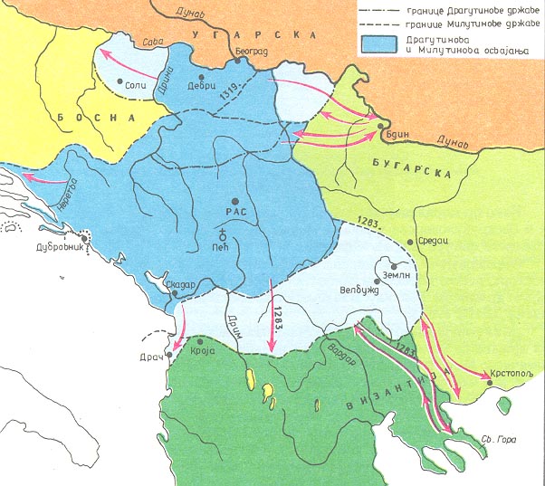
The Realm of Stefan DragutinSzablon:Cref2 (Szablon:Lang-sr / Oblast Stefana Dragutina) was a medieval Serb kingdom. Initially, it was a vassal kingdom of the Kingdom of Hungary,{{#invoke:Footnotes|sfn|template=sfn}} but subsequently became an independent kingdom, after the collapse of the central power in the Kingdom of Hungary. It was ruled by the Serbian kings Stefan Dragutin (1282–1316) and his son Stefan Vladislav II (1316–1325). The kingdom was centered in the region of Lower Syrmia (today known as Mačva) and its first capital was Debrc (between Belgrade and Šabac), while residence of the king was later moved to Belgrade.
Territory
In the Middle Ages, "Syrmia" was the name for a larger area around the river Sava. The part in the north of Sava was known as Upper Syrmia (present-day Syrmia), while the area south of the river was known as Lower Syrmia (present-day Mačva). The kingdom was centered in Mačva, but also included Belgrade, part of Šumadija with Rudnik, and the counties (župe) of Podrinje, Usora, Soli, Braničevo and Kučevo. According to several Serbian historians (Dejan Mikavica, Stanoje Stanojević, Aleksa Ivić, Milojko Brusin, etc.), the kingdom also included Upper Syrmia (modern Syrmia).
History
Stefan Dragutin was initially the king of Serbia from 1276 to 1282. In 1282 he broke his leg while hunting and became ill; he passed the throne to his younger brother Stefan Milutin at the council at Deževo in 1282, while keeping for himself some northern parts of the country (Rudnik and parts of Župa of Podrinje). Since his son Vladislav married a relative of the Hungarian king, Dragutin in 1284 gained from Ladislaus IV the Banates of Só (Soli), Ózora (Usora) and Macsó (Mačva) with Belgrade, which he initially ruled as a Hungarian vassal, until the collapse of the central power in the Kingdom of Hungary. The first capital of his state was Debrc (between Belgrade and Šabac), and later he moved his residence to Belgrade. Dragutin was the first Serb ruler who ruled from Belgrade as the capital.
In roughly 1291 and with the help of Milutin, Dragutin expanded his territory by annexing regions of Braničevo and Kučevo, whose Bulgarian rulers Darman and Kudelin recently became independent from the Kingdom of Hungary.[1] For the first time, that region became part of the Serbian state.{{#invoke:Footnotes|sfn|template=sfn}} This action probably caused the war between the Bulgarian despot Shishman of Vidin and Milutin.
Near the end of his life Stefan Dragutin separated from his Hungarian friends and strengthened his connections in Serbia. He later took monastic vows, and died 1316, buried at the Đurđevi stupovi monastery near Novi Pazar.
After king Dragutin died, his son Vladislav assumed his father's appanage. However, in 1319, Serbian king Milutin, Vladislav's uncle, invaded, defeated and imprisoned Vladislav. When Milutin died in 1321, the newly freed Vladislav recovered his father's lands, with the help of the Hungarians and Stephen II, Ban of Bosnia.Szablon:Cref2
After having been beaten again by supporters of Stefan Dečanski (successor of Milutin), Vladislav retreated to the Kingdom of Hungary in 1324. Vladislav's nephew, Ban Stephen II, reincorporated Soli and Usora into Bosnia. Belgrade and the northern part of Banate of Macsó along the river Sava remained under the rule of the Kingdom of Hungary, while Braničevo and the southern part of Mačva remained Serbian. The kingdoms of Serbia and Hungary would contest Mačva for the next century.
Rulers
| Monarch | Reign |
|---|---|
| 50px Stefan Dragutin |
1282–1316 |
| 50px Vladislav |
1316–1325 |
Annotations
Szablon:Cnote2 Begin Szablon:Cnote2 Szablon:Cnote2 Szablon:Cnote2 End
References
- ↑ Vásáry, István (2005). Cumans and Tatars: Oriental Military in the Pre-Ottoman Balkans, 1185-1365. Cambridge University Press. str. 104. ISBN 9780521837569. https://books.google.com/books?id=7DJWyg97IggC.
{{#invoke:Check for unknown parameters|check|unknown=|preview=Page using Template:Reflist with unknown parameter "_VALUE_"|ignoreblank=y| 1 | colwidth | group | liststyle | refs }}
Sources
- Bataković, Dušan T., ur. (2005) (French). Histoire du peuple serbe. Lausanne: L’Age d’Homme. https://books.google.com/books?id=a0jA_LdH6nsC.
- Ćirković, Sima; Mihaljčić, Rade (1999). Knowledge. https://books.google.com/books?id=AypYAAAAMAAJ.
- Dinić, Mihailo (1978). Српске земље у средњем веку: историјско-географске студије. Српска књижевна задруга. https://books.google.com/books?id=fnTTjgEACAAJ.
- Fine, John Van Antwerp, Jr. (1994). The Late Medieval Balkans: A Critical Survey from the Late Twelfth Century to the Ottoman Conquest. Ann Arbor: University of Michigan Press. ISBN 978-0-472-08260-5. https://books.google.com/books?id=Hh0Bu8C66TsC.
- Mrgić, Jelena; Živković, Tibor (2008). Северна Босна: 13-16. век. Историјски институт. https://books.google.com/books?id=hRoUAQAAMAAJ.
- Orbini, Mauro (1601). Il Regno de gli Slavi hoggi corrottamente detti Schiavoni. Pesaro: Apresso Girolamo Concordia. https://books.google.com/books?id=Fx3OntcdUkQC.
- Орбин, Мавро (1968). Краљевство Словена. Београд: Српска књижевна задруга. https://books.google.com/books?id=MduZAAAAIAAJ.
External links
- Map of Dragutin's and Milutin's state, at the Serbian Government archive web site
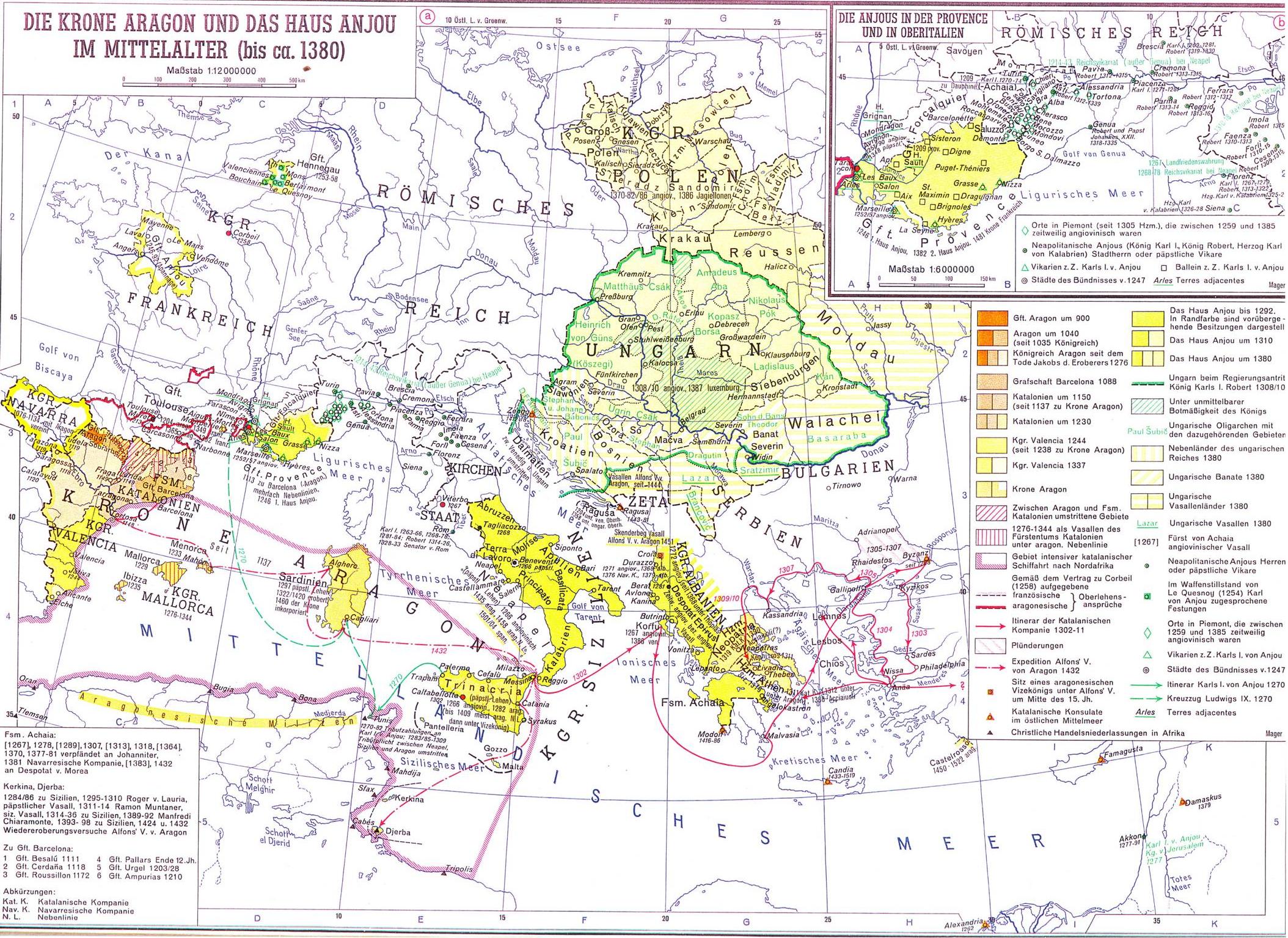
- Map of the realm of Stephan Dragutin, on a map of the crown of Aragon and the house of Anjou in the Middle Ages (up to ca. 1380)"
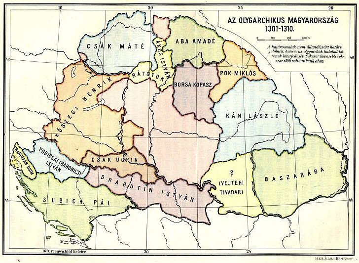
- Map of the realm of Dragutin Istvan, on a map of "Hungarian oligarchs" 1301-1310
- Map of "Tulso Szeremseg", on a map of the Kingdom of Hungary in the 13th century
- Szablon:Webarchive (from book "Hrvatska povijest u 25 karata", written by Stjepan Srkulj and Josip Lučić)
- Pages using infobox country with unknown parameters
- Strony z odwołaniami do nieistniejących plików
- Pages using reflist with unknown parameters
- Former countries in the Balkans
- Medieval Serbia
- Mačva
- History of Syrmia
- Medieval history of Vojvodina
- History of Belgrade
- Banate of Bosnia
- 13th century in Serbia
- 14th century in Serbia
- Kingdom of Serbia (medieval)
- Nemanjić dynasty